
WHITE ROCK, BC / ACCESSWIRE / November 14, 2023 / TDG Gold Corp. (TSXV:TDG) (the "Company" or "TDG") is pleased to report the results of the geophysical surveys completed in summer 2023 over TDG's 100% owned, high-grade gold ("Au") Mets mining lease, located in the Toodoggone District of north-central B.C.
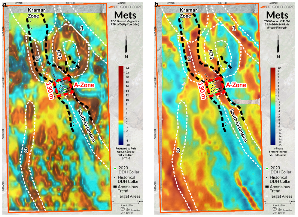
Ground Magnetic ("Mag") and Very Low Frequency Electromagnetic ("VLF") surveys were completed covering the entire Mets mining lease. In combination with historical diamond drilling2,3 results and geochemical surveys2, the new geophysical data identifies the known high-grade A-Zone at Mets within an anomalous trend (Figures 1a and 1b) traced over~1,300 metres ("m"). Furthermore, the surveys provide evidence that limited historical drilling2,3 within this trend appears to have been located too distal and/or too shallow to intersect the interpreted geophysical anomalies.
TDG's geophysics has also identified three new target areas1 on Mets where there has been no historical drilling. In total, TDG has now identified ~3,850 m of prospective trends within the Mets mining lease. Target1 generation will continue over the winter, with the aim of prioritising targets1 for a larger diamond drill program in 2024 focused on expanding the high-grade Au potential at Mets.
Steven Kramar, TDG's VP Exploration, commented: "Our geophysical surveys not only successfully characterized the structure that appears to control the high-grade mineralization within the Mets A-Zone but also identified several laterally extensive new target areas1 at Mets that have never been drill tested. The survey data also supports the potential for north and south extensions of the A-Zone, coincident with historical geochemical and geological data2."
TDG's 2023 Geophysical Program
Magnetic and Very Low Frequency electromagnetic geophysical surveys are useful tools for identifying magnetic and conductive geophysical features that can correspond to faults, structures and geological contacts that may host appreciable precious and/or base metal mineralization. TDG conducted a high-resolution, property-wide Mag-VLF survey over the Mets mining lease to characterize the geophysical signatures of the known high-grade Au mineralization around the A-Zone, and to use that signature as a tool to explore across the entire Mets property. This new geophysical data is supported by limited historical surface diamond drilling2,3, trenching2, soil sampling and ~350 m of underground development.
The most prominent feature from the survey is a pronounced multi-kilometer ("km") long, open ended Total Magnetic Intensity ("TMI") low (Figure 1a) that is coincident with the A-Zone mineralized area. District-scale airborne magnetic surveys conducted in the past suggests that this feature is part of a much more extensive north-northwest magnetic feature trending through and beyond the center of the Mets prospect - one of several similar features crossing the mining lease. Additionally, linear VLF conductive features (Figure 1b) have been identified coincident with the major north-northwest magnetic feature which could be an important orientation to control on mineralized structures. The survey also identified prominent geophysical anomalies coincident with historical geological2 and/or geochemical anomalies2. This has led to a delineation of potential drill target areas1 and a road map for exploration at Mets in 2024.
Existing Target Interpretation
Mets A-Zone (~130 m long)
The high-grade Au mineralization in the A-Zone can be characterized as a prominent TMI low with a corresponding defined linear VLF conductive zone. The magnetic feature is further supported by downhole magnetic susceptibility data, collected through the 2023 drill campaign by TDG (news releases Sept 07, 2023 and Sept 11, 2023) demonstrating the highest grades of Au mineralization encountered relate with downhole magnetic intensity lows.
The results from these methodologies (ground geophysics and drill core analysis) are further supported by multi-element geochemistry in soils and illustrate the close spatial relationship between magnetic mineral destruction, alteration, and the epithermal high-grade Au mineralization present at Mets.
South A-Zone Extension (~750 m long)1
The South A-Zone Extension (Figure 1 - South Extension) is defined by coincident strong VLF conductive feature, part of a multi-km long TMI low and an extensive, linear Au and silver ("Ag") in soil anomaly2 (Figures 2a and 2b) directly along strike and to the south of the A-Zone drilling area. A total of five shallow drillholes2,3 tested a very limited (30 m along strike) portion of this zone approximately 250 m south-southeast from the main A-Zone area in 1987, several of which intersected veining, alteration and Au-Ag mineralization. Based on the results of the recent geophysical surveys, historical drilling2,3 was likely collared too far west and did not test the most prospective target1 for higher grade mineralization. This target has a potential length of over 750 m based on the interpretation of the geochemistry2, geophysical data and limited drilling2,3 and is a high priority target for further step out drilling.
N75 Zone (~500 m long)1
A ~500 m diameter ovoid TMI high with a corresponding central TMI low occurs northeast of the A-Zone area (Figure 1 - N75). This feature may represent a former volcanic vent or hydrothermal center. A linear TMI low on the northeast flank of this feature (Figure 1 - Target Area 1) is along strike of, and coincident with, a VLF conductive feature very similar to that associated with the A-Zone. Only two holes have been drilled2,3 into this area and they were not in optimum locations to test the anomalous geophysical features.

Kramar Zone (375 m long)1
The Kramar Zone (news release Jan 19, 2023) is approximately 500 m by 475 m (Figure 1 - Kramar Zone) and was underexplored historically. Two historical drillholes2,3 were drilled into the very northern limits of this anomaly and both intersected broad zones ranging from 50-100 m of anomalous Au-Ag mineralization, within the anomalous zone and suggest further drilling on the main portion of the anomaly is warranted.
New Target Delineation1
Target #1 - Northeast Mets (~650 m long)1
Target 1 is located approximately 500 m northeast of the Mets A-Zone and extends beyond the limits of the survey grid in this area, having a minimum potential length on Mets of approximately 650 m (Figure 1 - Target Area 1). This target is defined by a distinctive linear TMI low, strong conductive VLF feature and corresponds to a linear historical Au and Ag in soils anomaly2 (Figures 2a and 2b). These features are very similar to the high-grade, drill-defined portion of the A-Zone and there has been no known drilling or trenching along this target.
Target #2 - North A-Zone Extension (550 m strike length)1
Located approximately 300 m west-northwest of the Mets A-Zone, this feature may represent a faulted offset of the A-Zone, displaced to the west. This feature extends at least 550 m and consists of a distinctive linear TMI low (Figure 1 - Target Area 2), strong conductive VLF response, and within a broad soil anomaly2(Figures 2a and 2b) connected to the A-Zone. This target had very limited drilling in the northern flanks, but the area with the strong geophysical response has not been drilled to date.
Target #3 - Mets Southwest (1,000 m strike length)1
This feature lies approximately 400 m southwest of, and is subparallel to, the A-Zone and (Figure 1 - Target Area 3) consists of a ~1,000 m long, linear TMI high and corresponding low, coincident strong VLF response and a large Ag-dominant Au-subordinate soil anomaly2 (Figure 2a and 2b). In addition, a 2007 BC Geologic Survey airborne radiometric survey outlines a strong potassium anomaly that could represent the airborne radiometric response associated with potassium feldspar alteration. This feature has never been drill tested.
About Mets
TDG's 100% owned Mets mining lease is located ~23 kilometres northwest of TDG's former producing Baker mine and mill. In October 2022, the Mets mining lease was extended for 30 years with support from local communities and a comprehensive table of significant historical intercepts from the A-Zone was published (news release Oct 19, 2022). In December 2022, TDG published a high-grade gold Exploration Target Range for Mets based on analysis of the 8,240 m of historical drilling and 2,600 m of historical trenching in combination with laboratory assay certificates from exploration undertaken in 1985-1991, detailed logs and reports from the underground development work completed in 1992, (news release Dec 21, 2022). In September of 2023, TDG published the first modern drill results from the A-Zone, intersecting high-grade Au mineralization over significant thicknesses (news releases Sept 07, 2023 and Sept 11, 2023).
Qualified Person
The geologically related technical content of this new release has been reviewed and approved by Steven Kramar, P.Geo., Vice President, Exploration for TDG and a Qualified Person, as defined under National Instrument 43-101.
1Mineral Exploration/Exploration Target Area(s): TDG is a mineral exploration focused company and the Company's Projects are in the mineral exploration stage only. The degree of risk increases substantially where an issuer's properties are in the mineral exploration stage as opposed to the development or operational stage. Exploration targets and/or Exploration zones and/or Exploration areas are speculative and there is no certainty that any future work or evaluation will lead to the definition of a mineral resource.
2Historical Data: This news release includes historical information that has been reviewed by TDG's qualified person (QP). TDG's review of the historical records and information reasonably substantiate the validity of the information presented in this news release; however, TDG cannot directly verify the accuracy of the historical data, including (but not limited to) the procedures used for sample collection and analysis. Therefore, any conclusions or interpretations borne from use of this data should be considered too speculative to suggest that additional exploration will result in mineral resource delineation. TDG encourages readers to exercise appropriate caution when evaluating these data and/or results.
3Historical Drill core Sampling & Assay Methodology: Historical drill core was geologically logged with lithologies identified and notable geological features recorded. Historical drill core was split in half (and in rare cases sawn in half) along sample intervals (lithology and mineralization dependant) generally less than 3 m. Chemical analysis was performed dominantly for precious metal analysis (Au and Ag), and infrequently for base metals (Pb, Zn, Cu), and rarely for major elements and trace elements. Historically, different commercial laboratories were utilized. These lab facilities may or may not have had accreditation and in all cases accreditation (if applicable) pre-dated current ISO standards. Over that period, a variety of digestion and assay methods were used, including atomic absorption, fire assay atomic absorption, aqua regia atomic absorption and aqua regia ICP with varying detection limits. Reference materials (if any) were inserted at the analytical level and thus were unblind to the facility processing the samples.
About TDG Gold Corp.
TDG is a major mineral tenure holder in the historical Toodoggone Production Corridor of north-central British Columbia, Canada, with over 23,000 hectares of brownfield and greenfield exploration opportunities under direct ownership or earn-in agreement. TDG's flagship projects are the former producing, high-grade gold-silver Shasta and Baker mines, which produced intermittently between 1981-2012, and the historical high-grade gold Mets developed prospect, all which are all road accessible, and combined have over 65,000 m of historical2,3 drilling. The projects have been advanced through compilation of historical2 data, new geological mapping, geochemical and geophysical surveys and, at Shasta, 13,250 m of modern HQ drill testing of the known mineralization occurrences and their potential extensions. In May 2023, TDG published an updated Mineral Resource Estimate for Shasta (news release May 01, 2023) which remains open at depth and along strike. In January 2023, TDG defined a larger exploration target area adjacent to Shasta (Greater Shasta-Newberry; news release Jan 25, 2023). In September 2023, TDG published the first modern drill results from the Mets mining lease (news releases Sept 07, 2023 & Sept 11, 2023).
ON BEHALF OF THE BOARD
Fletcher Morgan
Chief Executive Officer
For further information contact:
TDG Gold Corp.,
Telephone: +1.604.536.2711
Email: info@tdggold.com
Neither TSX Venture Exchange nor its Regulation Services Provider (as that term is defined in the policies of the TSX Venture Exchange) accepts responsibility for the adequacy or accuracy of this release.
Forward Looking Statements
This news release contains forward-looking statements that are based on the Company's current expectations and estimates. Forward-looking statements are frequently characterized by words such as "potential", "confirm", "identify", "characterize", "evidence", "coincident", "deduce", "likely", "support", "illustrate", "demonstrate", "correspond"," indicate","associate","favour","confidence","interpret","represent"and variations of these words as well as other similar words or statements that certain events or conditions "could", "may", "would" or "will" occur. Such forward-looking statements involve known and unknown risks, uncertainties and other factors that could cause actual events or results to differ materially from estimated or anticipated events or results implied or expressed in such forward-looking statements. Such factors include, among others: the actual results of current and planned exploration activities; results from future exploration programs including whether extensions to the A-Zone at Mets will be identified and whether the geophysical and/or geochemical anomalies and other targets represent mineralization of potential economic interest; that geological and/or geophysical anomalies remain open (in any direction); conclusions of future economic evaluations; accidents, labour disputes and other risks of the mining industry; the availability of sufficient funding on terms acceptable to the company to complete the planned work programs; delays in obtaining governmental approvals or financing; and fluctuations in metal prices. There may be other factors that cause actions, events or results not to be as anticipated, estimated or intended. Any forward-looking statement speaks only as of the date on which it is made and, except as may be required by applicable securities laws, the Company disclaims any intent or obligation to update any forward-looking statement whether, as a result of new information, future events or results or otherwise. Forward-looking statements are not guarantees of future performance and accordingly undue reliance should not be put on such statements due to the inherent uncertainty therein.
SOURCE: TDG Gold Corp.
View source version on accesswire.com:
https://www.accesswire.com/803020/tdg-gold-corp-identifies-multiple-new-targets-at-mets-toodoggone-district
